DEVICE SETUP
MAP DISPLAY OPTIONS
EDIT MAP DATA
IRIDIUM GO!
______________________________
TO SETUP YOUR IRIDIUM GO
-Start up the device and login to the Iridium GO App (or login to 192.168.0.1 through your browser)
-Click Settings
-Click Track
-Under ‘Tracking Recipient’ enter the tracking email provided in your signup email (note it will be .live not .com)
-Under tracking frequency select how often you want to send tracking updates.*
-Click save
You’re ready to track!
You can also add the tracking email to your ‘Quick GPS’ recipients lists. This will allow you to send tracking points at anytime, through either the app or directly from the GO. Which is useful for ensuring your final location is recorder before turning the unit off.
*If using a limited plan do not send updates more often than your plan allows (1, 4 or 12 hours), this will cause an error and your map will not be viewable. If this occurs then simply wait for your allowed time to pass and send a new update, your map will now be viewable again.
______________________________
ENSURING GOOD GPS SIGNAL
TRACKAmap offers tracking points accurate to within 5cm of your true location. However, accuracy is entirely dependent on your Iridium GO receiving good GPS signal. Poor signal can result in position updates that are 5kms or further from your true position. The GPS antenna is located inside the unit and is NOT improved by an external antenna. An external antenna only improves the connection for sending/receiving messages (which helps in the speed that your position updates are sent).
The best way to check the strength of the GPS signal is through the Iridium GO app. Open the app and click ‘TRACK‘ you should see a screen like this: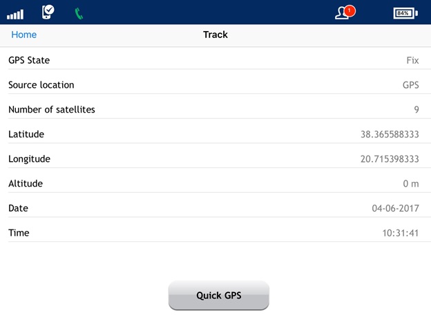
Important are:
GPS state: should be ‘fix’
Number of satellites: will vary but should be at least 8
Latitude/Longitude: more decimal places is better, at least 6
Altitude: Should be your current altitude (0 if at sea level).
If any of the details on your screen do not match the above requirements you are likely receiving a weak signal and will be sending low accuracy location data to TRACKAmap.
A quicker but less detailed method of checking GPS signal you can also look at the screen on the Iridium GO itself. It should have a tick next to the coordinates (not a cross) and show 4 decimal places.
The only way to improve the signal is by giving your Iridium GO a better view of the sky. So move it closer to a window/windshield, keep it high above the ground and do not cover it.
IRIDIUM EXTREME 9575
______________________________
TO SETUP YOUR IRIDIUM EXTREME
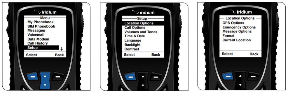
-Start up the device
-Click: Menu => Setup => Location Options => GPS Options
-Choose: GPS Update Options – ‘Real Time’ (Note if your device does not have external power then selecting a longer time frame will save battery power, at the risk of less accurate location updates)
-Choose: GPS On/Off – ‘Enabled’
-Go back to Location Options (Menu => Setup => Locations Options)
-Click: Location Options => Message Options => Regular Update => Update Frequency
-Choose the frequency of tracking updates (remember you will send one SMS per update)*
-Go back to Regular Update (Menu => Setup => Location Options => Message Options => Regular Update)
-Click: Regular Update => Update Recipient
-Enter the tracking email provided in your signup email (note it will be .live not .com) – The “*” key accesses “.” and “@”.
You’re ready to track!
You can also add the tracking email to your ‘Quick GPS’ recipients lists. This will allow you to send tracking points at anytime, which is useful for ensuring your final location is recorded before turning the unit off.
Setup: Menu => Setup => Location Options => Message Options => Quick GPS List =>(empty)=> Edit => enter the tracking email provided in your signup email.
To send: Press the right Convenience Key => Share => Quick GPS (screen will display ‘ SMS Message Sent OK’)
*If using a limited plan do not send updates more often than your plan allows (1, 4 or 12 hours), this will cause an error and your map will not be viewable. If this occurs then simply wait for your allowed time to pass and send a new update, your map will now be viewable again.
______________________________
ENSURING GOOD GPS SIGNAL
TRACKAmap offers tracking points accurate to within 5cm of your true location. However, accuracy is entirely dependent on your Iridium Extreme receiving good GPS signal. Poor signal can result in position updates that are 5kms or further from your true position.
The best way to check the strength of the GPS signal is through the location quick view screen . Press the right Convenience Button of the device, you should see a screen like this:
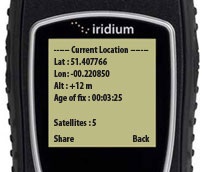
Important are:
Satellites: will vary but should be at least 7
Latitude/Longitude: more decimal places is better, at least 6
Altitude: Should be your current altitude (0 if at sea level).
If any of the details on your screen do not match the above requirements you are likely receiving a weak signal and will be sending low accuracy location data to TRACKAmap.
The only way to improve the signal is by giving your Iridium Extreme a better view of the sky. So move it closer to a window/windshield, keep it high above the ground and do not cover it.
https://youtu.be/kmyZM4i4tsk
GARMIN INREACH
– Login at inreach.garmin.com
– Select the ‘Social’ tab
– Click the ‘Feeds’ link
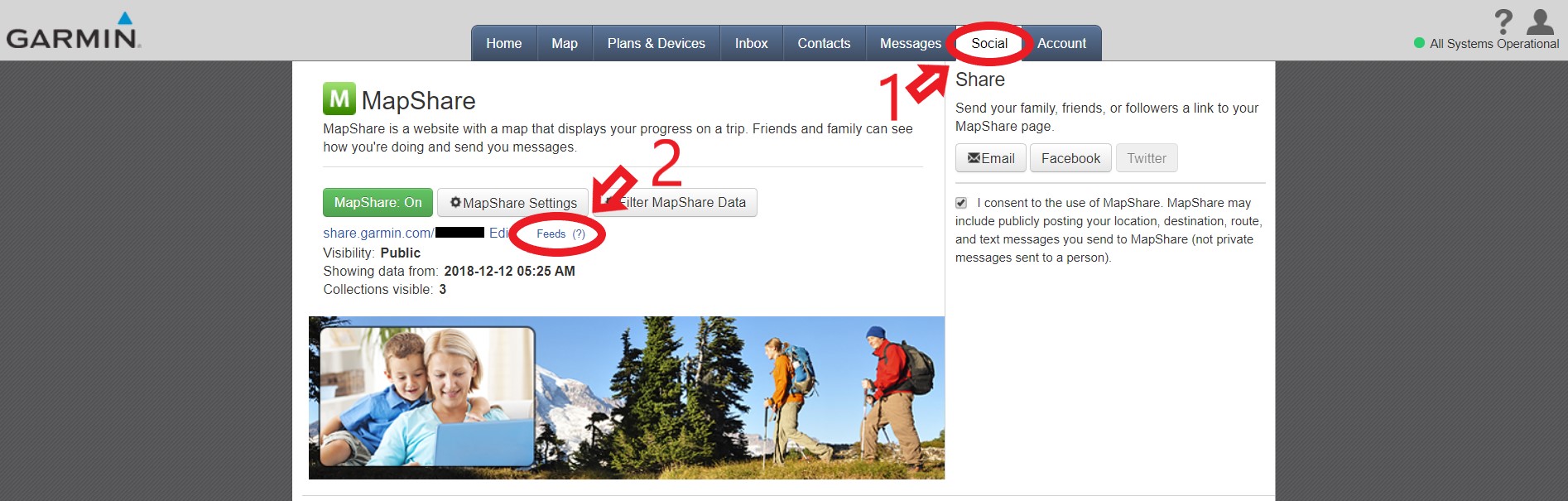
– Copy the ‘Raw KML Data’ link
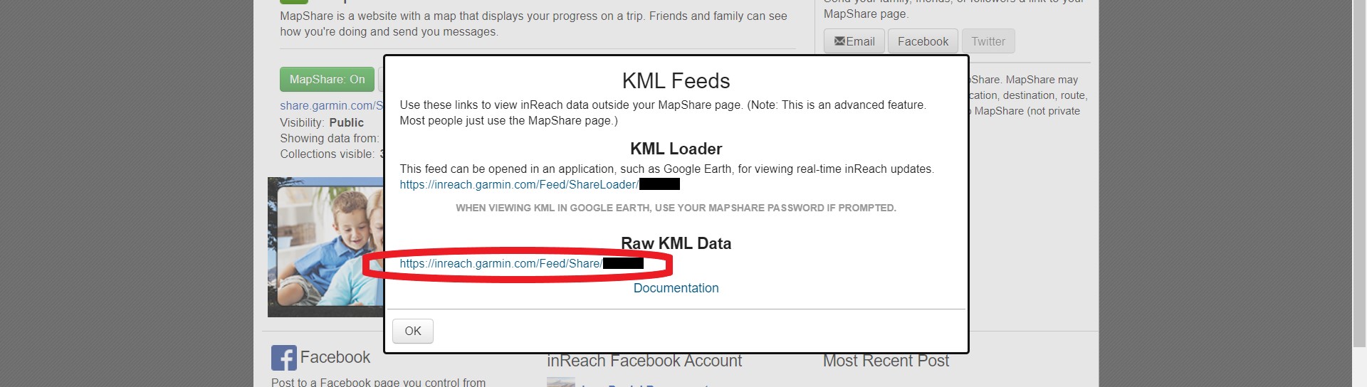
– If this link doesn’t show you may need to turn MapShare off then on again
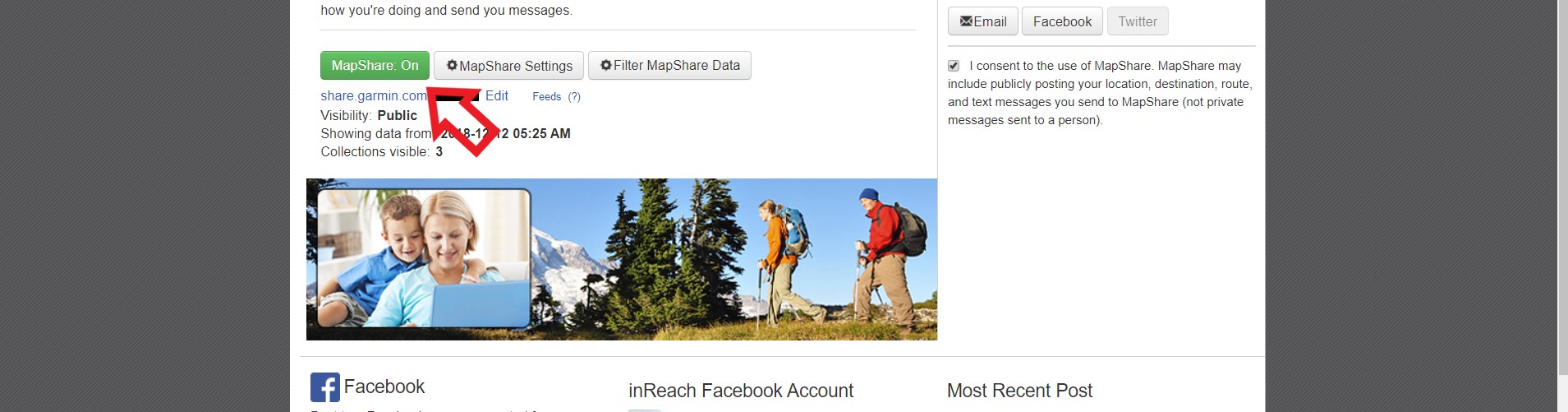
Insert this link into the signup form or under ‘Inreach URL’ in your TRACKAmap account settings page.
NOTE: In your account settings you can change the start date that TRACKAmap will begin displaying your data, however any other changes must be made within your MapShare account.
WEBSITE SETUP (EMBED YOUR MAP IN YOUR OWN SITE)
Your map is iframe compatible, so can be inserted on almost any website. Website builders such as Wix and Squarespace have HTML/iframe elements, or code can be inserted directly.
FULL PAGE
MAP SETTINGS (DEFAULT AND CUSTOM VIEWS)
LOGIN TO YOUR ACCOUNT – click the ‘Edit Account’ tab
NOTE: You can also alter the URL to display individual maps in the format you would like. These are listed below.
MAP SETUP OPTIONS:
InReach Share URL: For displaying an inReach track
Identifier: This is the name of what you are tracking and will show in a popup at your last recorded location
Default map style: The map style (Satellite/Street/Ocean/National Geographic/Topgraphical/Simple/Weather)
Include weather overlay?: Make the weather overlay viewable (cannot be turned on by page visitors)
Default weather overlay: Which style of weather to show (Wind/Temperature/Waves/Rain/Clouds/Current/Pressure/Off)
Zoom Level (8-14): 8 is distant view, 14 is close
Tracking line color: The color of the line
Line opacity: How transparent the line is
Line weight: How thick the line is
# Days to display? (default): The number of days back from today to begin showing your track, until the most recent location
Start date (default): The first date to show your track, until the most recent location
Tracking point color: Make all tracking points (dots) the same color
Display a different color for each year?: For longer tracks. A different color will show for tracking points of different years (overwrites ‘Tracking point color’)
Auto zoom in when stopped?: A closer view of your location when TRACKAmap calculates you’re stopped
Vague location when stopped?: When TRACKAmap calculates you’re stopped your exact location will not be shown
Map Password: Optional password for all users to enter when visiting your map page
URL VARIABLES TO UPDATE INDIVIDUAL MAPS:
These alter your map the same as the setup options above
Simply append the chosen variable using ‘?’ after your url.
Multiple variables can be joined using ‘&’.
Examples:
trackamap.com/boat/?map=ocean
trackamap.com/boat/?map=ocean&zoom=4
Default map style: map=satellite/street/ocean/natgeo/topo/simple/weather
Include weather overlay?: weatherdisplay=off
Default weather overlay: weather=wind/temp/waves/rain/clouds/current/pressure/off
Zoom Level (8-14): zoom=2/3/4/5/6/7/8/9/10/11/12/13/14
Tracking line color: line=red/green/yellow/blue/lavender/purple/cyan/magenta/lime/orange/teal/brown/beige/maroon/mint/olive/apricot/navy/grey/fuschia/pink/white/black
Line opacity: lineopacity=[number 0 – 1]
Line weight: lineweight=[number]
# Days to display? (default): startdays=[number]
Start date (default): start=[Date in format YYYY-MM-DD i.e 2015-03-20]
Tracking point color: dotc=red/green/yellow/blue/lavender/purple/cyan/magenta/lime/orange/teal/brown/beige/maroon/mint/olive/apricot/navy/grey/fuschia/pink/white/black
Display a different color for each year?: yearcolor=true
EDIT SPREADSHEET: TRACKING DATA
Your spreadsheets are linked directly to a database on our server, of which there is no backup. This gives you complete control over what data we store. Please create a copy of your existing data before making changes. TRACKAmap is not responsible for ensuring data is retained. We may contain some of your data in the original emails sent to us, if you would like to delete all stored data please contact us.
We do not recommend changing tracking spreadsheet details while actively live tracking. This may cause errors in transfer of data between our database and the spreadsheet.
ACCESS YOUR TRACKING SPREADSHEET
A link will be emailed to you on signup indicating you have been given access to two spreadsheets. One is your tracking data and the other is for additional data (icons). If your signup email is not associated with a Google account please contact us. If you wish to allow access to another account (to have someone else make changes) you can add them as an editor under the file share settings.
BASIC INSTRUCTIONS
The tracking spreadsheet has basic instructions included (in the top 7 rows), we recommend you don’t change these cells.
BLANK ROWS – NEW LINE
A blank row will start a new tracking line.
!!Do not have two or more blank rows in succession, this will cause errors!!
DATE TIME
This must be entered and must be in correct date-time format
We recommend copying an existing date cell to ensure correct format is maintained.
LOCATION
Can be left blank.
Additional data from Iridium tracking.
ALT (ALTITUDE)
Can be left blank.
Altitude in ft.
GPS SEEN
It is recommended to enter a ‘-‘ instead of leaving blank.
Additional data from Iridium tracking.
LAT / LON (LATITUDE & LONGITUDE)
These must be entered and must be in decimal degrees format (i.e 1.2345).
Note that minutes are 1/60 of a degree, so 1° 14.07′ = 1.2345° or 1° 14′ 4.2″ = 1.2345°
Be aware some external data (such as KML files) may be recorded in Lon, Lat.
Do not include the ‘+’ symbol, however ensure ‘-‘ is included if required.
TIP: While viewing your map you can right click to set a temporary point and left click this point to copy coordinates.
ENTERED BY
Can be left blank but we recommend using this, for organizational purposes.
Displays in popup.
ICON
Must be entered.
The color of the marker, options are:
red, green, yellow, blue, lavender, purple, cyan, magenta, lime, orange, teal, brown, beige, maroon, mint, olive, apricot, navy, grey, white, fuschia, pink, black*
* automatically displayed when you stop in a location (send multiple updates with the same coordinates)
Please let us know if you are interested in using pictorial icons, this was a previous feature that has been removed.
NOTES
Can be blank.
This is displayed in the popup.
Multiple columns are provided for organisation only, there is no difference visually.
Update your tracking data manually. Add or remove tracking points including prior to holding a TRACKAmap subscription
DISTANCE KM / DURATION
Can be blank.
These are calculated when live tracking.
EDIT SPREADSHEET: ADDITIONAL ICONS (Photo/Video/Blog)
Your spreadsheets are linked directly to a database on our server, of which there is no backup. This gives you complete control over what data we store. Please create a copy of your existing data before making changes. TRACKAmap is not responsible for ensuring data is retained. We may retain some of your data in the original emails sent to us, if you would like to delete all stored data please contact us.
Have a request for a new icon type? Contact us!
ACCESS YOUR TRACKING SPREADSHEET
A link will be emailed to you on signup indicating you have been given access to two spreadsheets. One is your tracking data and the other is for additional data (icons). If your signup email is not associated with a Google account please contact us. If you wish to allow access to another account (to have someone else make changes) you can add them as an editor under the file share settings.
ICON OPTIONS
Currently we offer the following icons:
VIDEO
PHOTO
BLOG
INSTAGRAM
MOUNTAIN
EXTRAS
New CUSTOM COLOR icons! simply include a Hex color at the end of the title, examples:
#ff0000
Waypoint #66eeff
Data will be displayed with a black marker if it doesn’t fit these categories.
NEW ICON SHEET
Initially your additional data spreadsheet includes one sheet ‘PHOTO’. All data entered on this sheet will have a photo icon. To display different icons make a duplication of this sheet and rename it to the required icon style (must be capitals)
If you would like to organise data with the same icon you can create multiple sheets with different titles, so long as they contain the icon type in capitals (i.e ‘USA BLOG’ and ‘Africa BLOG’).
All columns are optional, except location.
DATE
This must be entered in the correct date-time format (1/30/2000 1:00:00)
Will display on mouse-over and in the popup.
TITLE
Will display on mouse-over and in the popup.
DESCRIPTION
Will display in the popup.
LAT / LON (LATITUDE & LONGITUDE)
These must be entered and must be in decimal degrees format (i.e 1.2345).
Note that minutes are 1/60 of a degree, so 1° 14.07′ = 1.2345° or 1° 14′ 4.2″ = 1.2345°
Do not include the ‘+’ symbol, however ensure ‘-‘ is included if required.
TIP: While viewing your map you can right click to set a temporary point and left click this point to copy coordinates.
IMAGE
A URL link to a publicly accessible image. Must begin with https:// or http://
This will display in the popup.
URL
A URL link to a publicly accessible location. Must begin with https:// or http://
The popup will link to here.
MESSAGES
A live message/blog feature is currently being tested. Simply SMS or email track@globaltracking.live from your device (note this email will change after testing). Your message will display in the top right corner of your map. There is no location information saved with your message and messages will be ordered by the time sent. The last 5 messages will be displayed with all messages shown at trackamap.com/**identifier**/blog (linked from your map).
To edit, delete or add messages click the ‘BLOG’ tab of your tracking data spreadsheet (link is sent on signup)
EMAIL TRACKING UPDATES (Iridium 9555)
NOTE THIS FEATURE IS CURRENTLY UNDERGOING TESTING
INITIAL SETUP
The email (or emails) which you are sending data from must be associated with your map. Please contact us to set this up.
SEND EMAIL OR SMS-TO-EMAIL
The message should be sent to the same address as your regular tracking updates (provided on signup).
Please ensure no signature is included in your email. This will either cause errors or will display as part of your message in the popup.
MESSAGE LAYOUT
!!! It is vital to ensure the message is written as instructed. Any other format will be rejected by the server !!!
**SMS*LAT*LON*NAME*MARKER*MESSAGE
IMPORTANT – All stars ‘*’ must be entered. We recommend copying and pasting to ensure correct layout every time.
1: **SMS
Start with 2 stars ‘*’ and ‘SMS’ to identify the message as an SMS map entry.
2: *LAT*LON
The coordinates of your current position in decimal degrees format (i.e 1.2345).
Note that minutes are 1/60 of a degree, so 1° 14.07′ = 1.2345° or 1° 14′ 4.2″ = 1.2345°.
Do not include the ‘+’ symbol, however ensure ‘-‘ is included if required.
NOTE: Only enter your current or most recent location. The timestamp from your Email/SMS will be used to order tracking points.
3: *NAME
Displayed as “Entered by NAME” in the popup.
Used to record who made the entry. i.e your name.
4: *MARKER
The marker color of your tracking point. One marker can be used for all messages or you may choose to use different markers to represent different actions. (For example markers that have a message included)
red, green, yellow, blue, lavender, purple, cyan, magenta, lime, orange, teal, brown, beige, maroon, mint, olive, apricot, navy, grey, white, fuschia, pink, black*
* automatically displayed when you stop in a location (send multiple updates with the same coordinates)
5: *MESSAGE
Type the message you want to send.
A message isn’t necessary. i.e you may just want to mark a point on the map.
IRIDIUM GO USERS: The total length of the SMS can be maximum 1000 characters. You can see how many characters you have used in the corner of the SMS screen.
IRIDIUM 9555 USERS: The total length of the SMS can be maximum 160 characters.
Avoid using terms related to location i.e:
latitiude, longitude, lat, lon, altitude, alt, ft
EXAMPLE MESSAGE
**SMS*39.6417*-19.9037*John Smith*orange*This is the message to display